Google Maps polygons with JavaScript are an effective way to visually represent areas on a map. Whether you’re marking regions, outlining boundaries, or highlighting specific zones, polygons offer versatility and clarity to your map displays. Let’s give you tips for creating Google Maps polygons with JavaScript.
Introduction to Google Maps Polygons with JavaScript
Google Maps Polygons with JavaScript allows developers to create customizable shapes on maps, enhancing visualization and interaction capabilities. This guide explores essential techniques and best practices for effectively implementing polygons on Google Maps using JavaScript.

Setting Up Your Environment
Before diving into Google Maps polygons, ensure you have a suitable development environment set up. This typically involves including the Google Maps JavaScript API in your project and obtaining an API key for authentication and usage tracking.
Creating a Basic Polygon
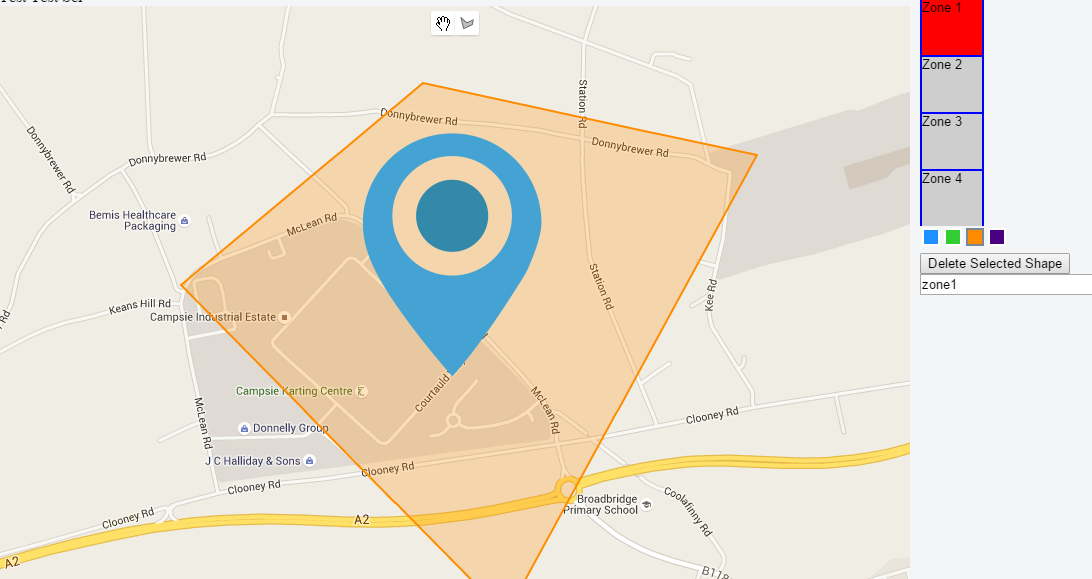
To create a polygon on Google Maps, start by defining the vertices or coordinates that outline the shape. Use the google.maps.Polygon the class provided by the API, which allows you to specify points, stroke styles, fill colours, and other properties to customize the appearance of your polygon.
Styling Your Polygons
Customize the visual aspects of your polygons using styling options available in the Google Maps API. You can adjust stroke colours, opacity, fill colours, and add animations or hover effects to enhance user interaction and map aesthetics.
Adding Interactivity
Make your polygons interactive by adding event listeners to respond to user actions such as clicks or mouseovers. This capability is useful for displaying additional information or triggering actions related to specific map areas represented by the polygons.
Handling Complex Shapes
Google Maps polygons support complex shapes beyond simple triangles or rectangles. Use arrays of coordinates to define more intricate boundaries, such as irregular polygons or multi-part shapes representing distinct geographic areas.
Optimizing Performance
Ensure optimal performance by considering the number of vertices and complexity of your polygons. Limit excessive points and use simplified shapes where possible to maintain smooth map rendering and responsiveness, especially on mobile devices.
Benefits of Using Google Maps Polygons
Clear Visualization
Polygons provide clear visual representations of geographic areas, making them ideal for displaying regions, boundaries, or areas of interest on interactive maps.
Customization Options
Google Maps API offers extensive customization options for polygons, including colour schemes, transparency levels, and interactive behaviours, allowing developers to tailor map displays to specific project requirements.
Data Integration
Integrate polygons with dynamic data sources to visualize real-time information, such as demographic data, sales territories, or environmental zones, directly on Google Maps.
Practical Applications
Real Estate Listings
Use polygons to outline property boundaries or highlight neighbourhoods, providing prospective buyers with spatial context and visual clarity when browsing real estate listings on maps.
Urban Planning
In urban planning and development projects, polygons help visualize zoning regulations, development areas, or infrastructure plans. Hence, facilitating stakeholder engagement and decision-making processes.
Environmental Mapping
Map environmental features or protected areas using polygons to educate the public or support conservation efforts by displaying habitats, reserves, or ecological zones on interactive maps.
Best Practices for Implementing Polygons
Plan Your Polygon Structure
Before implementation, plan the structure and purpose of each polygon to ensure they effectively convey information and meet user expectations on the map.
Test Across Devices
Verify polygon functionality and performance across various devices and screen sizes to ensure a consistent user experience, particularly in responsive web applications.
Conclusion
In conclusion, leveraging Google Maps polygons with JavaScript empowers developers to create engaging and informative map displays. By following these tips and best practices, you can effectively utilize polygons to enhance spatial visualization, interactivity, and data representation in your web applications.


